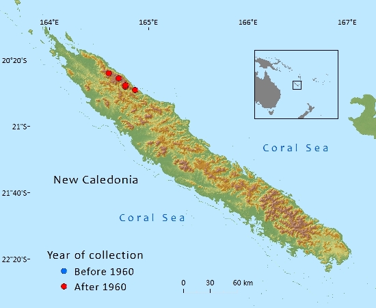
Araucariaceae

Agathis montana de laub.

Endemic to the Mt. Panié range in northern New Caledonia where recent research has found that the decline and loss of old-growth trees is probably due to a combination of factors including root damage by feral pigs, pathogen attack and climate change.

Distribution

Endemic to New Caledonia in Province Nord where it is restricted to the Mt. Panié range. Its known locations are from the higher (above 1,000 m above sea level) altitudes of Mt. Panié, Mt. Colnett and Mt. Ignambi (Jaffré et al. ,1987). Agathis montana has also been recorded (MacKee 34469 (P), 22/12/1977) from the summit of the Roches de la Ouaième, a separate range facing Mt. Panié. This specimen was originally collected by J.-F. Cherrier but deposited under H.S. MacKee's collecting numbers. It was collected from a small tree at 950 m. Despite recent field botanical surveys (Munzinger, 2013) that included canopy surveys, no further observations or collections have been recorded from this locality, suggesting that this tree may be single and isolated. Local indigenous people have mentioned that this individual tree is well known to them and “has a story”, suggesting it may have been planted by their ancestors. There is thus some doubt about whether this tree should be considered as a natural occurrence. While the most recent guidance from IUCN on introduced subpopulations indicate that those that are geographically close to the known native range of the taxon being assessed should be included in any assessment, the guidelines also clearly state that such introductions must have produced viable offspring (IUCN Standards and Petitions Subcommittee 2014 p.7). As there is no indication of this, the Roches de la Ouaième locality is excluded from calculations of the extent of occurrence (EOO) and area of occupancy (AOO).

The overall EOO, (using herbarium records but excluding the single tree on the Roches de la Ouaième), is estimated to be 90 km2 with an estimated AOO of 32 km2. The estimate for the extent of occurrence uses coordinates taken from gazetteers to georeference older herbarium specimens. There is some uncertainty about how accurate the estimations are. The AOO is estimated using the standard IUCN recommended 2 km x 2 km grid – this is very likely to be an overestimate.

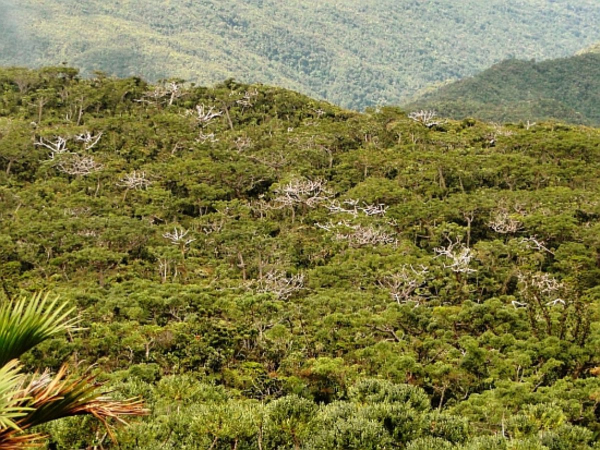
Agathis montana grows in mono-specific stands in the canopy above 1200 m on the north-eastern slope and above 1300 m on the south-western slope; all known trees seem to grow on slopes less than 35°. Using these data to model its range produces an estimated potential AOO of ca 1200 ha for the main population. When the few isolated trees growing down to 1000 m are included the estimate rises to ca 5,000 ha. Agathis montana forms a single subpopulation spread over a narrow altitudinal band on three peaks located within 20 km of each other along a single ridgeline.

Data on population size are based on 14 plots randomly established in October 2012 within 200 m of the Mt. Panié trail. Each plot is 50 m x 50 m, which represents 3.9% of the study area and 0.3% of the main A. montana range. Median density of trees >10 cm DBH (some of them may not yet be mature) is 83 trees/hectare (average = 104, min = 40, max = 356, standard deviation = 77) (Texier 2013). The total population may therefore be ca 100,000 mature trees. Based on 70 subplots of 10 m x 10 m designed to assess regeneration (saplings and young trees <10 cm DBH), median regeneration density is ca 3,000 individuals/hectare (average = 4,400, min = 0, max = 18,300) (Texier 2013).

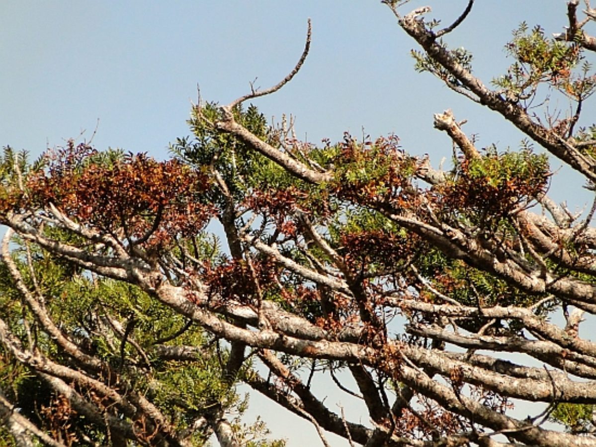
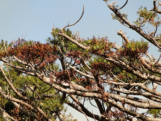
A recent and apparently rapid decline in the population has been directly observed since at least 2009. It may have commenced somewhat earlier but the exact timing is uncertain. Photos taken by the New Caledonian botanist J.-M. Veillon in 1969 show few if any dead trees; those taken in 1996 by the herpetologist T. Whitaker do show some dead trees especially near the summit of Mt. Panié. Aerial photos taken in 1991, and studied by the main author of this assessment, appear to show some dead trees but the photos are of insufficient quality to allow a reliable quantitative analysis of the mortality at this date. Henri Blaffart, head of Mt. Panié conservation programme (2002-2008), and who visited the summit area many times during that period, did not report any kauri decline. Foreign botanists from various research organizations such as Institut de Recherche pour le Développement, Missouri Botanic Garden, the Royal Botanic Gardens Kew and the Royal Botanic Garden Edinburgh who also visited the area between 2002 and 2007 did not report any decline either. The previous IUCN assessment, published in 2010 but based on information collated up until 2007, stated that "Currently, no specific threats have been identified. Climate change impacts such as changes in precipitation patterns could be a problem in the future" (Thomas 2010).

A decline was first formally reported to the main author of this assessment in September 2009 by an indigenous local guide during a helicopter survey of the area (E. Vaiadimoin pers. comm.). Mt. Panié has always been a privileged but difficult destination for tourists and scientists, usually accompanied by local indigenous guides (four guides used to accompany ca 50 ascents per year in the late 2000s, (Anonyme 2011); these guides have thus an historical understanding over changes happening in this area. While this was the first formal record of the decline, they estimated in 2010 ‘it may have started some years ago’. Other members of the main local tribe have also reported that they had noticed a recent decline in the tree. In September-October 2012, 14 random plots were established along Mt. Panié trail (Texier 2013), containing 363 large trees (DBH >10 cm). Sixty seven of them (18.5%) were dead (health score = 6); of the live trees, 57 (19.2%) were showing significant die-back symptoms (health score = 4 or 5). In February 2014, 10 of those plots theoretically containing 257 trees were re-surveyed (Sabran and Tron 2014). Two hundred and thirty five were actually found and monitored; most of the 22 trees not found in 2014 are likely to have been overlooked because they might have fallen on the ground, considering their poor health in 2012 (10 were actually already dead). Out of the 235 monitored trees, 202 trees were alive in Oct 2012; amongst them, 10 were dead in February 2014, suggesting an annual mortality rate of 3.7% per year. Overall, 20.5% of monitored trees are now dead. While 42.6% of monitored live trees were assessed as healthy (health scores = 1 or 2) in October 2012, this percentage had declined to 15.6% in Feb 2014. Seven of the 10 trees that died between October 2012 and February 2014 had a health score of 3 or 4 in October 2012. Forty four (27.2%) of the live trees now have a health score that represents a relative decline of two or more points over the monitoring period. These data suggest a significant and rapid decline.

Using the available data (of the 192 live trees remaining in our monitoring programme, 10 are projected to die every 16 months), an 80% population reduction of trees >10 cm DBH would happen within 21 years. Using population structure data from 2012 survey, we estimate nine new trees from the regeneration cohort would reach 10 cm DBH within the next 21 years: this is insufficient to replace the losses. Within 100 years (which is way below three generation lengths) there would be no mature trees left. Considering the significant reduction of many tree's health between October 2012 and February 2014 and sampling/monitoring biases (see below) resulting in an underestimation of mortality rate, the decline might be faster. These projections are based on limited data recorded over a relatively short period of time.

Notes on sampling and data reliability:

Helicopter flights in 2009 and 2011, as well as preliminary 2012 aerial images analysis, suggest that mortality is significant over the entire southwestern slope and all along the main ridgeline. The same approach suggests that lower altitude stands (i.e. between 1200 and 1300 m) on the northeastern slope are less affected. The four non monitored plots had – in October 2012 - a higher mortality rate, suggesting the proportion of dead trees may be higher over the entire 2012 study area: most of the 12 live trees from October 2012 that were not found in February 2014 are likely to be dead considering their poor health in October 2012, suggesting the mortality rate quoted here may actually be higher than 3.7% per year. Based on the information presented here the species could qualify for a threatened listing based on criterion A4bce, however, due to the small sample size of plants in the monitoring area and the limited time period for which the situation has been monitored, it was decided that there was too much uncertainty about the long-term trend to use this information in the assessment of this species.

Habitat and Ecology

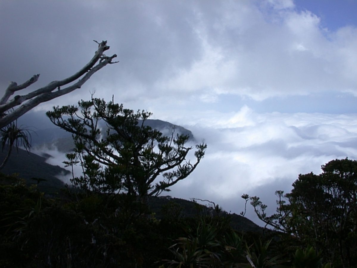
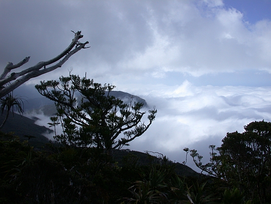
Most trees grow in mono-specific stands in the canopy above 1300 m on the SW slope and above 1200 m on the NE slope. Below that, only a few isolated individual trees are seen down to 1000 m (de Laubenfels, 1972). This elevation range seems to correspond to a cloud layer that envelopes this part of the mountain most of the time.

Agathis montana forms near-monospecific stands that dominate the canopy between 10 and 25 meters above ground. It probably plays a significant role (=keystone species) in filtering sunlight and maintaining humidity and thus creating a unique habitat. Most other plant species grow up to 3-5 meters, creating a very thick understorey (Tron and Texier 2013). Several micro-endemic plant species (Wulff 2013) and insects (Grandcolas et al. 2008) are known from this habitat, one of the most important for micro-endemism in New Caledonia (Wulff 2013) and now internationally recognized as a "Key Biodiversity Area" (Conservation International 2011).

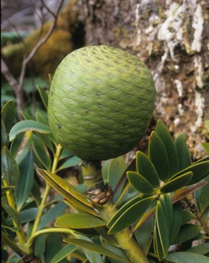
One recently dead tree of 80 cm diameter was estimated to be aged 1,100-1,300 years based on Carbon 14 dating methods (GNS Science 2012). Life-span is therefore suspected to be well over 1,000 years (Tron and Texier 2013). Based on this information and assuming linear growth, annual diameter growth is expected to be 0.7 mm/year. Fruiting is irregular and few observation have been made; however, maturity may be reached when trees are 20-30 cm DBH. Generation length may be ca 500 years. Regeneration is very dense in the understorey, but very few of them reach maturity (Texier 2013). From casual observations, regeneration looks sparse or may even be absent when mature A. montana are dead: most dead trees are in eroded areas.

Agathis montana produces a dense, fine and highly ectomycorhized feeder-roots matt within the first 5 cm of the soil (Tron and Texier 2013).The soil is silty and shallow (<50 cm) and seems to be the product of the bedrock (schist) and litter degradation. It is therefore particularly sensitive to erosion. It does not grow on purely rocky substrate outcrops.

The population dynamics of the family Araucariaceae are thought to involve, or even be dependent on severe landscape scale perturbations like cyclones or bushfires (Enright et al. 1999). This may explain some of the results of the original population structure surveys from 2012 (Texier 2013).

Human Uses

Agathis montana is called “Dayu Biik” in Némi and Fwaî, two local dialects. The translates as “strong and flexible Kauri” in reference to its ability to withstand strong winds. Its is also considered by some indigenous people with land rights on Mt. Panié as the guardian of the place and trees have a cultural importance in relation to the spirits of the local people's ancestors. Dayu Biik is also the name of a secondary, but very sacred peak within the Mt. Panié range. Several legends refer to the place where A. montana grows.

The indigenous organization in charge of the management of Mt. Panié wilderness reserve, is named after A. montana. They hence have a key cultural responsibility in caring for that species in particular. Agathis montana is an iconic species, often displayed on pictures promoting New Caledonian biodiversity and landscape.

Along with other Agathis spp. its gum is used by local guides as fuel for campfires. Trees may be grown as ornamentals, but mostly in specialist collections.

Conservation Status

Global status

Critically Endangered B1ab(iii,v)

Global rationale

Agathis montana is a long lived conifer (generation length may be ca 500 years) restricted to a single subpopulation in one location in the higher elevations of the Mt. Panié range in Province Nord, New Caledonia. The extent of occurrence is estimated to be 90 km2 and a population decline and habitat degradation have been observed over the last five years and is projected to continue. Agathis montana is therefore considered Critically Endangered under the B1 criterion.

Twenty percent of the trees within the area of a monitoring programme are already dead: 5% of mature monitored trees died between October 2012 and February 2014, suggesting a projected population reduction of 80% within the next 21 years and a likelihood of there being no mature trees left in 100 years. An assessment under Criterion A4 was considered but has not been used due to the small sample size and the limited time period for which the situation has been monitored.

Several factors may be contributing to the decline and habitat degradation. Foraging invasive pigs disturb soil leading to increased erosion of the thin and vulnerable soil as well as the death of the fine feeder roots of the kauri trees causing stress. Feral pigs are also known to be vectors of pathogens which may be attacking the weakened trees. A Phytophthora species with affinities to the one linked to extensive die back of New Zealand Agathis australis has been recorded on A. montana trees that are showing evidence of decline. Recorded increases in temperature and potentially altered cloud regime may lead to an increase in water stress. Recent regional droughts, concurrent with the recorded increase in temperatures and combined with the impact of feral pigs and Phytophthora may be jointly causing the decline.

Conservation management includes pig control and is due to start in 2015. Further research into other causes of the decline is needed.

Global threats

Four threats and factors are suspected to be involved in the decline of this species (Tron and Texier 2013):

1) Feral pigs: in searching for food in the soil, feral pigs disturb moss, litter and the surface horizon that contains the fine feeder roots of kauris, creating a first stress to kauris. In 2012, within the 14 random plots 95.6% trees had pig uprootings, with an average of 8.5 uprootings per tree. Dead feeder-roots can be recognized as dead when they appear grey rather than the normal red when they are alive and healthy. Many dead feeder roots have been recorded in areas damaged by pigs. This disturbance also causes significant erosion, sometimes down to the bedrock, which permanently damages roots, especially the fine feeder-roots; many anchoring roots now emerge out of the ground. In eroded areas where many kauris have died, other vegetation looks less dense, vital and varied. Trees may then suffer water and mineral stresses, likely becoming more vulnerable to pests and pathogens and overall leading to dieback of the trees and eventually death. Feral pigs are also known to spread soil-borne diseases, including Phytophthora cinnamomi in New Zealand (Krull et al. 2012). The first introduction of pigs to New Caledonia dates back to the arrival of James Cook's fleet in 1774 and several releases have occurred since then throughout New Caledonia. Local indigenous people report a recent (ca over the last 10-20 years) population increase in feral pigs, possibly in relation to limitations on the ownership of guns and ammunition and changes in hunting practices that have led to a reduction in hunting effort and range. Similar changes have been reported in many other parts of New Caledonia.

2) Disease: an unidentified Phytophthora species was found in July 2012 (PlantWise 2014). While its exact taxonomic position is not yet known, it is known that it is not P. cinnamomi and has been identified as a member of the same clade that includes the Phytophthora linked to extensive dieback in New Zealand Agathis australis forests (Phytophthora Taxon Agathis). It is currently uncertain whether it is a native or introduced, and whether it is a primary or secondary pathogen. Biosecurity measures have never been requested at the entrance of Mt. Panié reserve.

3) Insects: two bark beetles species (most likely Hylurgus sp. and Hypocryphalus sp. Hulcr pers. comm.) were found in July-October 2012 on trees showing signs of dieback. Their exact taxonomic position is not yet known and it is uncertain if they are native or introduced, or are acting as primary or secondary pests.

4) Climate change: an analysis of local weather records (from a weather station based 10 km away, at sea level) shows a temperature increase of 1°C over the last 40 years and a significant drought in the period 2003-2007 (Casola and Tron 2013). Similar increases have been reported across New Caledonia (Maitrepierre et al. 2008). Temperature increase may alter the cloud regime possibly leading to a lowering of the cloud upper limit (areas above 1,300 m regularly emerge from the clouds) and thereby exposing the Agathis forests to a different microclimate with less humidity. Higher temperatures and less humidity may cause a significant water stress on A. montana; the genus is considered particularly vulnerable to it (Delzon and Brodribb in review). In French Polynesia, feral pigs move and forage more intensively at higher altitude during droughts, where they also have a significant impact on soil and vegetation (J.F. Buteau pers. comm.). Water stressed trees would be more vulnerable to pests and pathogens, possibly leading to die-back and eventually to death.

Local indigenous guides and local senior botanists report that a thick moss layer (20-50 cm thick) used to cover large parts of the ground: it is now restricted to small and isolated patches. During the 1970s, the French army felled a significant number of trees on the summit of Mt. Panié and built a wooden hut in order to facilitate helicopter and troop exercises: many old dead trees are clustered around this clearing. Some local indigenous people consider that taboos involving Mt. Panié have been breached and are one of the causes of the decline.

There is no doubt that the threats and factors mentioned above have led to a decline at least in the quality of habitat. The non quantitative and preliminary observation of geographical heterogeneity of the mortality (see comments in Population section) suggests that some environmental factors not yet fully understood explain part of the decline.

Conservation Actions

Conservation of A. montana is a specific objective of the first Mt. Panié wilderness reserve management plan. Some resources have been allocated for pig control & yearly monitoring (Anonyme 2011) but these now seem insufficient.

In 2012, implementation of Year 1 of the management plan involved the following activities; a field visit from Dr. Nick Waipara (Waipara 2012), sampling of tissues and pathogen identification (PlantWise 2014), tree architecture study (Texier 2013),establishment of monitoring plots and protocols (Texier 2013) and assessment of management options (Tron and Texier 2013). To date, pig control has been identified as the most realistic management option. Feral pig control should start in 2015 while other conservation strategies, including research are being considered.

Mt Panié reserve contains ca 30% of A. montana's main range (ca 350 of 1,200 hectares). A wider community consultation was started in 2013 to mobilize all concerned stakeholders in agreeing an extension to the reserve so that appropriate conservation management can be undertaken at that scale.

References and further reading

  1. Anonyme. 2011. Plan de gestion de la Réserve de nature sauvage du Mont Panié.
  2. Casola, J. and Tron, F. 2013. Interannual precipitation and temperature variability near Mt. Panié wilderness reserve and its connection to kauri (Agathis montana) die-back. In: F.M. Tron, R. Franquet, T.H. Larsen and J.J. Cassan (eds), Evaluation rapide de la biodiversité du massif du Panié et des Roches de la Ouaième. RAP bulletin of Biological Assesment 65, Conservation International, VA, USA.
  3. Conservation International. 2011. Delineation of Key Biodiversity Areas in New Caledonia. Noumea.
  4. de Laubenfels, D.J. 1972. Gymnospermes. (4). Flore de la Nouvelle-Calédonie et Dépendances., pp. 167. Muséum National D'Histoire Naturelle, Paris.
  5. Enright, N.J., Ogden, J. and Rigg, L.S. 1999. Dynamics of forests with Araucariaceae in the western Pacific. Journal of Vegetation Science 10: 793-804.
  6. GNS Science. 2012. Radiocarbon calibration report for Conservation International New Caledonia.
  7. Grandcolas, P., Murienne, J., Robillard, T., Desutter-Grandcolas, L., Jourdan, H., Guilbert E. and Deharveng, L. 2008. New Caledonia: a very old Darwinian island? . Philosophical Transactions of the Royal Socety B 363: 3309-3317.
  8. Jaffré, T. and Munzinger, J. 2009. Conservation status of Araucaria schmidii and Agathis montana. Email correspondence with IUCN SSC Conifer Red List Authority Focal Point.
  9. Jaffré, T., Morat, Ph., Veillon, J.-M. and MacKee, H.S. 1987. Changements dans la végétation de la Nouvelle-Calédonie au cours du Tertiaire: la végétation et la flore des roches ultrabasiques. Bulletin du Museum National d'Histoire Naturelle. 4e Serie. Section B. Adansonia 9: 365-391.
  10. Jaffré, T., Munzinger, J. and Lowry, P.P. 2010. Threats to the conifer species found on New Caledonia's ultramafic massifs and proposals for urgently needed measures to improve their protection. Biodiversity and Conservation 19: 1485-1502: DOI 10.1007/s10531-010-9780-6.
  11. Krull, C.R., Waipara, N.W., Choquenot, D., Burns, B.R., Gormley, A.W. and Stanley, M.C. Absence of evidence is not evidence of absence: Feral pigs as vectors of soil-borne pathogens. Austral Ecology 38(5): 534–542. doi:10.1111/j.1442-9993.2012.02444.x.
  12. Maitrepierre L. and S. Caudmont. 2007. Atlas climatique de la Nouvelle-Calédonie. Météo-France - Direction interrégionale en Nouvelle-Calédonie et à Wallis-et- Futuna, . Nouméa.
  13. Munzinger J. 2013. Inventaire botanique du massif du Panié et des Roches de la Ouaième, province Nord, Nouvelle-Calédonie. In: F.M. Tron, R. Franquet, T.H. Larsen and J.J. Cassan (eds), Evaluation rapide de la biodiversité du massif du Panié et des Roches de la Ouaième, province Nord, Nouvelle-Calédonie. RAP Bulletin of Biological Assessment 65 , Conservation International, Arlington, VA, USA.
  14. Sabran, C. and Tron, F. 2014. Dépérissement des Kaoris (Agathis montana) du Mont Panié. Bilan du suivi de février. Rapport de mission Dayu Biik & Conservation International.
  15. Texier, N. 2013. Caractérisation du peuplement et de la mortalité d’Agathis montana de Laubenfels (Araucariaceae) au sein de la réserve de nature sauvage du Mont Panié, Province nord, Nouvelle Calédonie : approche architecturale et écologique. Rapport de stage M2 AMAP.
  16. Thomas, P. 2010. Agathis montana. In: IUCN 2013. The IUCN Red List of Threatened Species. Version 2013.2. Available at: www.iucnredlist.org. (Accessed: 21 April 2014).
  17. Tron, F. and Texier, N. 2013. Etude de faisabilité pour la lutte contre le dépérissement d’Agathis montana. Rapport de Conservation International pour Dayu Biik et la Province nord.
  18. Waipara, N. 2012. Preliminary symptomology assessment of Agathis montana dieback at Mont Panié Wilderness Reserve - A report from a field visit support, July 10-18, 2012.
  19. Wulff, A. 2012. Le micro-endémisme dans un hotspot de biodiversité: approche globale sur la flore vasculaire de la Nouvelle-Calédonie et analyse comparative au sein du genre Scaevola. Thèse de doctorat de, 226 pp. l’Université de la Nouvelle-Calédonie.